By Adam Pagnucco.
In a prior column, I noted the participation of many county Republican Party leaders in the Nine Districts group. These leaders even went so far as to use the party’s official website to raise money for the Nine Districts campaign fund. Why is the GOP’s local leadership so interested in eliminating at-large county council seats and replacing them with nine districts?
The answer is simple: nine districts might be the only way they can get a Republican elected to the county council.
It’s important to remember that the council has not always been unanimously Democratic. District 1 (Bethesda-Chevy Chase-Potomac) elected two Republican council members: Betty Ann Krahnke (1990-2000) and Howard Denis (2000-2006). District 2 (Upcounty) was represented by Republican Nancy Dacek from 1990 through 2002. Those were the days when Republican Congresswoman Connie Morella represented most of MoCo – a much less partisan time. District 2, which represents much of Upcounty, is the most Republican-heavy council district in the county. Its current seat holder, Council Member Craig Rice, has won his last three general elections with 59% of the vote in 2010, 60% of the vote in 2014 and 71% of the vote in 2018. The shift of the GOP from being the party of Morella to the party of Donald Trump has brought hard times to local Republicans.
Nine districts could resuscitate the party. That’s because a change from five districts to nine districts could allow enough Republicans and independents to congregate into one district to make it competitive in a general election. That is clearly what the county’s Republican leadership is hoping for. But could it actually happen? Could dark blue MoCo – even the reddest one-ninth of it – ever elect a Republican again?
To test that hypothesis, I pulled precinct-level data from the 2018 general election. I used the following criteria to select precincts that would form the most Republican-intensive district possible in the county:
Lowest percentage of registered Democrats
Highest percentage of registered Republicans
Lowest percentage of actual voting Democrats
Highest percentage of actual voting Republicans
Lowest percentage of votes going to Democratic council at-large candidates
Highest percentage of votes going to Republican council at-large candidates
There were two additional requirements. First, the precincts had to be geographically contiguous. (No random splatters of territory like Maryland’s Third Congressional District!) And second, the precincts had to contain one-ninth of the county’s registered voters, which I used as a proxy for population.
In practice, this turned out to be pretty easy since 23 precincts met all six of the above criteria. Two more met five criteria, three more met four criteria and two more met two criteria. Two precincts met none of the criteria but they had to be included to make the district contiguous. A few others did well on qualifying criteria too but were either non-contiguous or created difficulty in keeping the district at the appropriate size. All of this reinforces a central fact: in MoCo, partisanship is heavily geographic.
And so here it is: 32 precincts containing 73,269 eligible voters as of the 2018 general election, almost exactly one-ninth of the total registered voters in the county. (Again, I’m using registered voters as an admittedly imperfect proxy for population.)
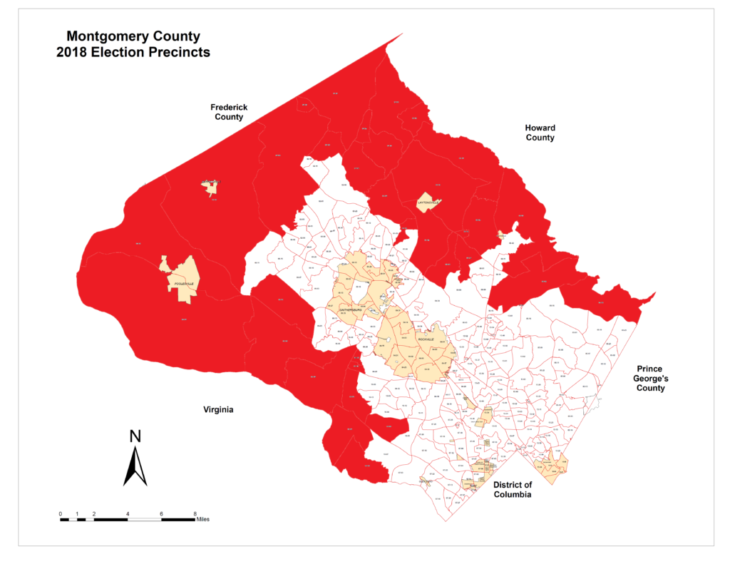
Let’s call this the Red District. Here is what it looks like on a map.

The Red District has the shape of a jagged “C” and hugs the western Potomac River, the Frederick County border and the Howard County border. Its largest communities are Clarksburg, Damascus, Poolesville and part of Potomac. It is not geographically compact, but it does have a community of interest because it includes the least dense, and most rural, parts of the county. Its shape was inevitable. These are the areas where Republicans are strongest and Democrats are weakest.
How would the Red District have voted in the 2018 general election? We will find out in Part Two.
