By Adam Pagnucco.
My post on MCPS’s Insane School Boundaries is rapidly becoming one of the most-read posts in the two-and-a-half year history of Montgomery Perspective (and my nearly 20 years as a public writer). Folks from all over the county are pouring in to see what it means for their communities. And since the starting maps cover Downcounty, the core of MoCo’s Democratic voter base, the implications might be politically explosive.
Ground zero might be Kensington.
First, some context on the earlier post. MCPS released four options for high school and middle school maps in the vicinity of Charles W. Woodward High School, which will soon be reopening in North Bethesda. Because the school is new, high school and middle school boundaries will need to be adjusted across a broad geography between North Bethesda, Aspen Hill, Inner Silver Spring and Bethesda. Each of the four options released by MCPS emphasizes one of its four priorities in devising boundary adjustments: demographic characteristics of student population, geographic proximity of communities to schools, stability of school assignments over time and facility utilization in the 80-100% range. My hunch is that MCPS won’t select any of these options whole-cloth, but rather pick a combination of them based on feedback.
The outlier option is Option 3, which is based on balancing student demographics between schools. As chronicled in my first post, implementing that priority without regard to the others produces a bewildering maze of islands, tentacles and other weird shapes best confined to abstract art. But here’s the thing, folks – MCPS is never going to approve it straight up. Other priorities besides demographics matter too and MCPS will never want to deal with the blowback of adopting a Jackson Pollock painting as its school boundaries.
Now to Kensington. Currently, the town is divided between three high schools. The unincorporated area north of the Connecticut/University intersection is served by Albert Einstein HS. Through Einstein, residents there have access to the rest of the Downcounty Consortium including most schools in Silver Spring. The incorporated Town of Kensington and the neighborhood between Rock Creek and Cedar Lane is served by Walter Johnson HS in Bethesda. And the portion of Kensington south of the incorporated town is served by Bethesda-Chevy Chase HS.
Why does this division matter? Consider the following information from MCPS’s Schools at a Glance series (2022-23).
Einstein HS: Asian 7%, Black 15%, Latino 50%, White 23%, English language learner 19%, free and reduced price meals 47%, average SAT score 1031.
Bethesda Chevy Chase HS: Asian 7%, Black 17%, Latino 21%, White 49%, English language learner 8%, free and reduced price meals 23%, average SAT score 1203.
Walter Johnson HS: Asian 12%, Black 13%, Latino 18%, White 50%, English language learner 6%, free and reduced price meals 17%, average SAT score 1192.
These are major differences, especially between Einstein and the other two.
Now consider the four option maps.
Option 1: North Kensington stays with Einstein. The rest of Kensington goes to Walter Johnson. None remains in Bethesda Chevy Chase.
Option 2: Similar to Option 1 but a tiny sliver along Beach Drive to the south stays in Bethesda Chevy Chase. My hunch is that few people if any live in that sliver.
Option 3: Nearly all of Kensington is assigned to Einstein while that tiny sliver to the south around Beach Drive stays in Bethesda Chevy Chase.
Option 4: Same as Option 1, at least in the case of Kensington.
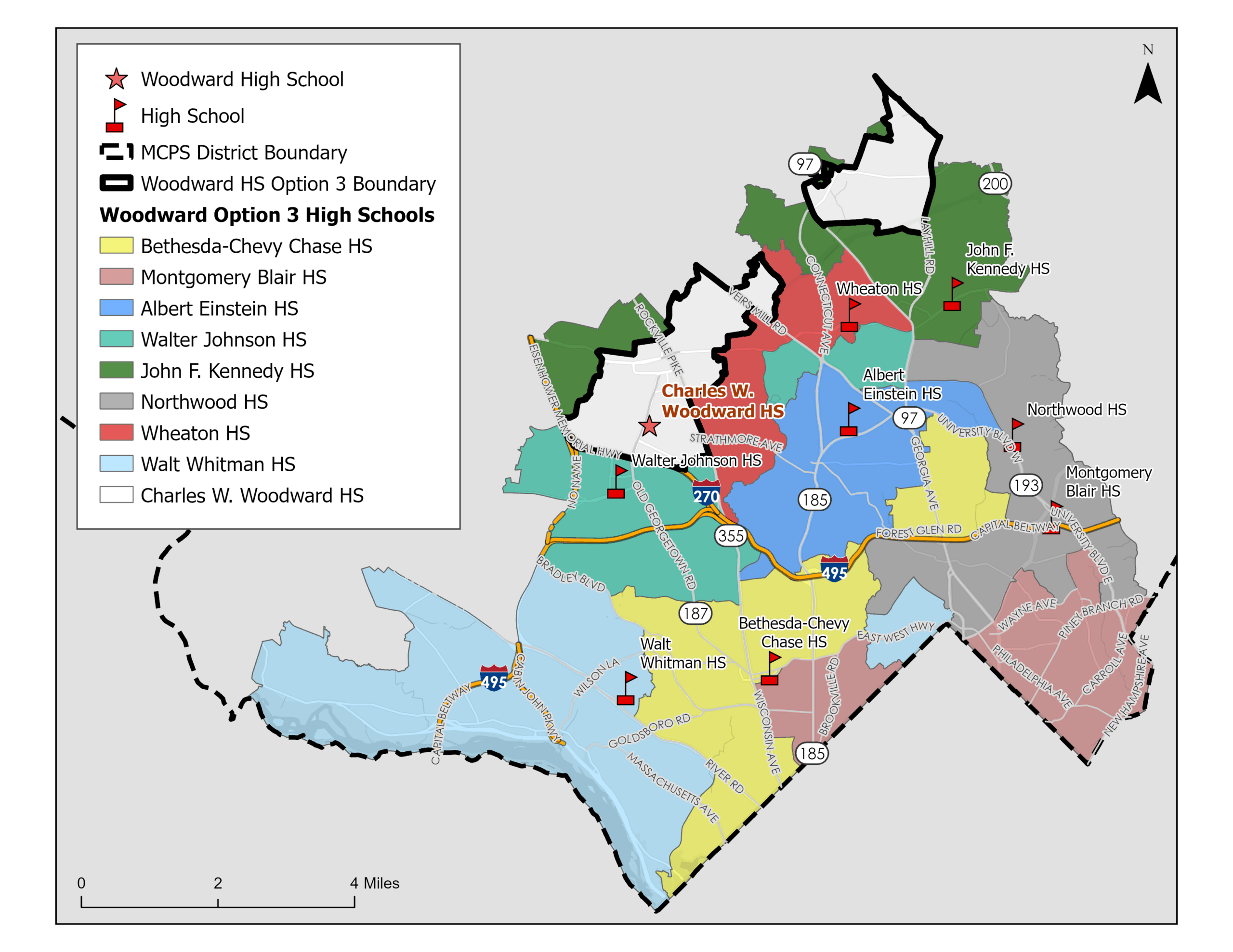
Option 3 has Einstein (in dark blue) serving nearly all of Kensington.
Option 3, which accounted for my earlier “insane maps” post, clearly causes the most change. But under all four options, access to Bethesda Chevy Chase disappears for all or nearly all south Kensington residents. The area of change is concentrated around Silver Creek Middle School, which is itself new (having opened in 2017). For families in that area, that’s an awful lot of boundary shifting in a short amount of time.
The middle school maps also contain many changes across all four options, likely expanding the scope of parental concern.
Kensington is a smallish area in MoCo’s geography, but in political terms, it punches far above its weight. It is home to U.S. Senator Chris Van Hollen and Council Member Gabe Albornoz, has an influential town government, is the core of State Legislative District 18 (along with Chevy Chase) and has a formidable concentration of high-turnout precincts. It’s not an area I would take on if I were a MoCo politician.
And because of the changes described above in all four boundary map options, it just might be ground zero of the newly launched MCPS boundary war.