By Adam Pagnucco.
In the wake of its calamitous release of boundary map options for the vicinity of Charles W. Woodward High School, MCPS has now released high school and middle school maps for the areas between Potomac and Damascus. Once again, strangeness abounds and perhaps voices will be raised.
MCPS is analyzing high school and middle school boundaries in two study areas which together comprise roughly three quarters of the county. (Elementary school boundaries are not changing… for the moment.) The first study area is chronicled in the link above. The second study area saw maps released yesterday. Their vicinity is in the area of a new Crown High School in Gaithersburg and an expansion to Damascus High School (which is currently delayed).
The impacted communities include Potomac, North Potomac, Darnestown, Poolesville, Rockville, Gaithersburg, Germantown, Montgomery Village, Clarksburg, Damascus and numerous smaller areas. Impacted high schools include Winston Churchill (in Potomac), Clarksburg, Damascus, Gaithersburg, Northwest (in Germantown), Poolesville, Quince Orchard (in Gaithersburg), Richard Montgomery (in Rockville), Seneca Valley (in Germantown), Watkins Mill (in Gaithersburg and Montgomery Village) and Thomas S. Wootton (in Rockville and Potomac). It’s a huge swath of MoCo which exceeds the size of most counties in Maryland.
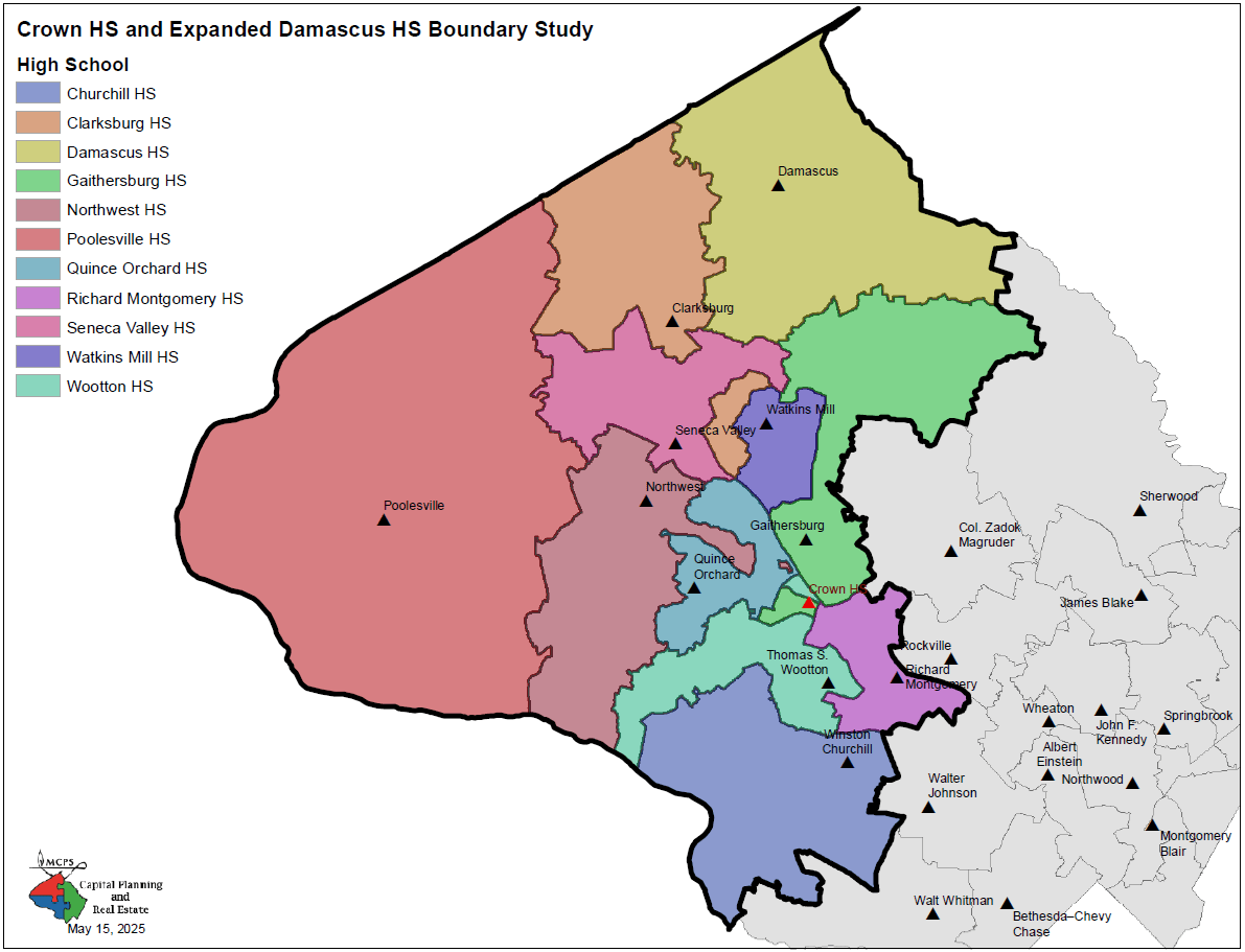
First, let’s acknowledge that the existing boundaries (shown below) are odd. Four high schools (Clarksburg, Gaithersburg, Northwest and Wootton) have islands. Wootton and Gaithersburg have strange shapes while Northwest extends a tentacle deep into Quince Orchard’s vicinity. There must be interesting history in the initial formation of these boundaries.
As with the earlier round of maps, this study contains four options, each one emphasizing one of the district’s priority factors in boundary studies. These are demographic characteristics of student population, geographic proximity of communities to schools, stability of school assignments over time and facility utilization in the 80-100% range.
One of the key factors in the design of these maps is the service area of Crown High School, a new school which has yet to open. The school building itself will be located to the east of the Downtown Crown development in the City of Gaithersburg and is just west of the I-270/Shady Grove Road interchange. Crown’s service area changes dramatically across the four option maps and that has consequences for surrounding schools.
For Crown itself, its position around I-270 will have a significant impact on its student body. Gaithersburg west of I-270 trends higher income and Asian. Gaithersburg east of I-270 trends lower income and Latino.
In Option 1 and Option 4, Crown’s service area is confined to west of I-270. The area east of I-270 is served by Gaithersburg HS and Richard Montgomery HS, as it is now. In Option 2 and Option 3, Crown’s service area is on both sides of I-270. That affects Gaithersburg HS in particular, and in Option 3, Gaithersburg HS’s service area extends far to the west of I-270 almost to the backyard of Quince Orchard HS.
As with the Downcounty maps, Option 3 (which emphasizes student demographics) produces the weirdest shapes. Take a look at the Option 3 map below.
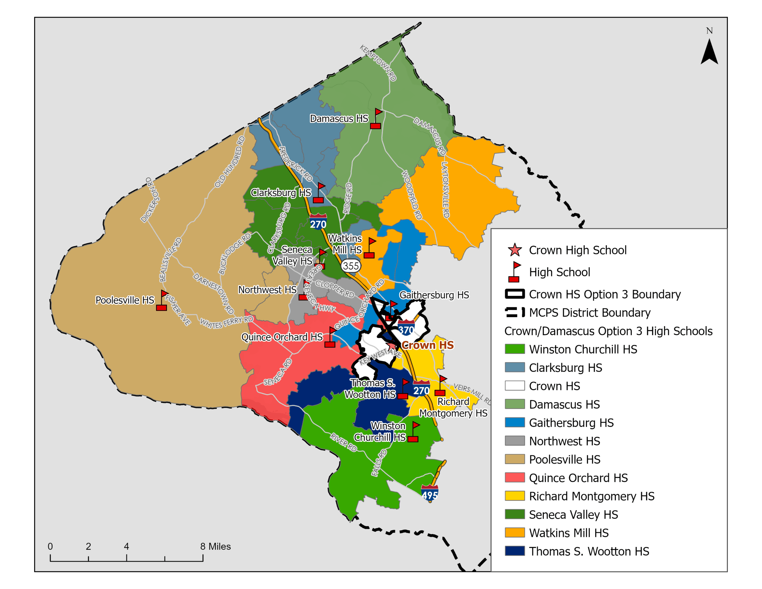
Wootton HS, in dark blue, is a large-headed, decapitated snake with its tail touching the Potomac River and its mouth poised to chomp on I-270. Gaithersburg HS (moderate blue) is a chopped up intestinal worm curling around from north of Watkins Mill HS to lightly graze the rump of Quince Orchard’s building. No doubt readers can imagine their own strange creatures splaying their limbs across the area, perhaps with some assistance from Jack Kirby or J.R.R. Tolkien.
There is more, and it’s not all confined to Option 3. For example:
In every option, Northwest HS loses a cluster of high-income areas near the Potomac River to Quince Orchard HS. That will impact the demographics of both schools.
Watkins Mill HS adds rural areas to its northeast in Options 3 and 4. That may mean shorter bus rides for many of these students, who currently attend Gaithersburg HS, but it will also affect the demographics of both schools.
The fate of the Rio island, which currently sends students to Wootton despite its closer proximity to Gaithersburg HS, varies between maps. In Options 1 and 3, it stays in Wootton. In Options 2 and 4, it goes to the new Crown HS. And which kind of Crown HS it goes to varies a lot, because Crown is entirely west of I-270 in Option 4 and goes across I-270 in Option 2. I’m sure Rio parents will have opinions about this.
Wayside Elementary School in Potomac currently feeds into Churchill HS, one of MCPS’s most prominent schools. In all four options, it would now feed into Wootton HS.
Many of these changes don’t seem as dramatic as those found in the Downcounty maps, which are now causing quite a ruckus – especially in Kensington. But they are substantial nonetheless. Let the hues and cries ascend in pitch as this discussion – reflecting the quintessential tribalism of MoCo – hurtles towards its fateful conclusion.