
By Adam Pagnucco.
Here’s a quest that will never be resolved in my lifetime: the search for a perfect data series. It simply doesn’t exist. In the field of economics, that applies to every subject that comes to mind: employment, income, gross domestic product, business growth and well, everything else. It makes economic analysis challenging to say the least.
Here’s an example: building permits, which is often regarded as a primary source of data on housing construction. Three years ago, I used U.S. Census data on residential building permits to argue that MoCo had just recorded its worst year of housing construction on record. The county government promptly challenged that post on the grounds that Census data on building permits was inaccurate, and it was right: the county had not been reporting its permits to Census for years, causing Census to rely on estimates that turned out to be wrong. I demanded accurate data and so did the county council. Eventually, the county’s Department of Permitting Services (DPS) provided updated data to the council’s Office of Legislative Oversight but there was a problem: the new data did not include years before 2019, which contradicted the data the county had earlier provided to me. It was the biggest mess I had ever seen on a county data issue, and the historical issue remains undecided at this writing. In addition, here is a big question: even if Montgomery County is now reporting accurate data to Census, could other counties be screwing up in the way we once did? How would we know?
Economic analysis is more painful than it looks, folks!
Housing is too important of a subject to give up the quest for good data, so I found another source: U.S. Census data on address counts. As part of the decennial census and other interim programs like the American Community Survey, Census maintains a residential address list which is primarily sourced from the U.S. Postal Service (USPS). This list is regularly updated to reflect development. Census relies on it to deploy its foot soldiers to residences every ten years as well as to mail out American Community Survey forms. It then releases it for every Census block in the country. Data starts with April 2020 and has been released in July and November of 2023 and later years.
In our county, the planning department is responsible for assigning addresses of new developments. One source described the process in this way:
Addressing is established at the time of record plat – in the form of an address verification, a new address assignment, or a full addressing plan, depending on the nature of the development. Often times, developers come to us before submitting their record plat applications, so that the addressing information can be included in their record plat submissions. We then communicate all new address assignments and updates to USPS on a monthly basis via email. It is our understanding that USPS takes a week or two to enter those updates into their system.
Once USPS has the new addresses, they are then transmitted to the Census Bureau.
Theoretically, this data could be used as a proxy for housing construction. It would have the benefit of bypassing the problems of irregular reporting by building permit offices to Census, which bedeviled our permits data as seen in my account above. However, this data source is also imperfect. When I told one of my top sources in land development that I intended to collect this data, the person offered this opinion to me.
Thinking about this some more, to the purpose for which you intend to use the USPS data, it’s possible there could be a decent number of addresses recognized by the USPS that don’t actually represent built units or even units under construction yet…
If the addresses are assigned at record plat and logged by USPS shortly thereafter, it could be quite a while before the applicant goes through the permitting process and construction of those units. There could be units that they don’t build for years, or never build. Then the address would be associated with a vacant parcel.
If my source is right, then this data is more reflective of planned construction than actual construction. It’s a big caveat in analyzing what it really says. However, it comes from one agency applying the same methodology to every square inch of the United States while bypassing the problematic reporting of building permits. Imperfect though it may be, it’s probably better than nothing. And housing is too important to source data on its production to anecdotes of ribbon cuttings by self-interested politicians!
This data has one more problem: it’s about as user-friendly as a Russian drone strike. Take a look at how it appears in its raw form. Do you see anything that says, “Silver Spring had 500 new addresses last year?”
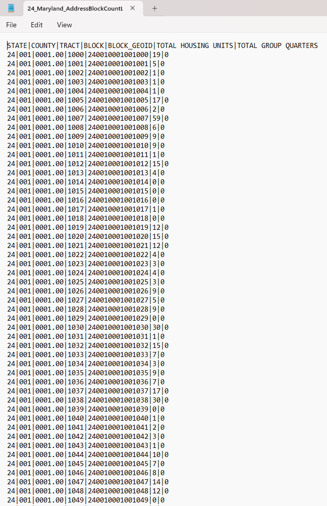
Nope! It’s just a bunch of geocodes. I spent many dozens of hours translating geographic code numbers into state and county names and – in the case of MoCo data – into zip codes as well. I had to do this for more than a million records. This was an excruciating process. The many politicians who wish evil upon me should toast my misfortune at undertaking it.
Migraines aside, the end result of this analysis is that I now possess residential address counts for D.C., Maryland, Virginia, all Maryland counties (including the City of Baltimore) and all jurisdictions in the Washington-Arlington-Alexandria metro area for April 2020, July 2023, November 2023, July 2024, November 2024 and July 2025. In MoCo, I translated Census block codes into zip codes which I can now use for micro-analysis. (This is how I know that block code “24|031|7015.05|2002|240317015052002|176|1” is in Silver Spring.) And when updates of this data come out, I should be able to incorporate them with less trouble because the code crosswalks have now been built.
So what does all of this data say about us and our neighbors? We shall begin finding out next!